Orumieh Lake - West Azerbaijan
+41 More Photos
Tourist Attraction

Orumieh Lake

in Orumieh city | West Azerbaijan province
Tourist Attraction

Orumieh Lake

Related to Orumieh city (West Azerbaijan Province)
Also known as: Lake Urmia, Daryache-ye Orumiye
Orumieh Lake - West Azerbaijan
The province of West Azarbayjan has the largest lake of Iran in its territory, known as Lake Orumieh. This lake is at an altitude of 1,267 m. from the sea level, with a length of 130-140 km, the width being approximately 15-50 km. and at an average depth of 50-60 m.

Its waters are extremely salty (twice the salinity of the oceans), consequently the lake never freezes. From olden times, local physicians made use of the water (because of its mineral content) and coastal sludge, in treating skin diseases and rheumatoid disorders. The best season for bathing in these waters are from the end of June till the third week of August, when the lake begins getting cold.

Lake Orumieh (Daryacheh Urmia) has numerous islands, both large and small totaling to 102 in number. The most important of these being the following, Kaboodan (Qoyoon Daqi), Ashk, Espeer, and Arezoo.
 
-orumieh lake-lake of oromieh-orumieh lake-urumieh lake-oroumie lake-urumia lake-urmia lake-darayeche oroumieh-daryache urumie-urmia lake-lake or oromieh-lake or oroumieh-ourumieh lake-
The level of water at Lake Urmia, a body of water located in northwestern Iran, is unprecedented for the past 10 years


Urmia Lake Bridge:
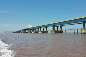
It is the largest and longest bridge in Iran, and crosses Lake Urmia, connecting the provinces of East Azerbaijan and West Azerbaijan. The project was completed in November 2008. The bridge reduced the driving distance between Tabriz and Urmia by 135 kilometres (84 mi).


Kaboodan Island:
This island is one of the largest islands of the lake Orumieh, located to the east of which and covering an area of about 3,175 hectares. Its vegetation being generally short scrubs and a variety of trees bearing wild fruits and nuts. Mammals such as wild goat and wild sheep exist on this Island. It is protected by the Department of the Environment as a National Park.

Ashk Island:
This island lies to the south of the Island of Kaboodan and 40 km. from the port of Golman Khaneh. This island has a 'sweet water' spring and provides a natural habitat for resident and immigrant birds. One of the rarest species of wildlife known as the 'Iranian follow deer' is found here. The Island covers and area of 2,115 hectares and its vegetation is similar to that of the Island of Kaboodan.

Espeer Island:
This island covers an area of 1.151 hectares, located to the west of the Kaboodan island and 27 km. from the port of Golman Khaneh. This island provide a natural habitat for birds. The island also has one jetty. These islands have facilities for swimming and water sports.
Fullscreen Map
PHOTO GALLERY
Orumieh Lake - West Azerbaijan
30
More Photos
Orumieh Attractions & Tourist Information
The township of Orumieh (Urmiah) lies between the western banks of the Lake Orumieh and the country of Turkey. The capital of which is the city of Orumieh. This city is located 951 km from Tehran and 13 km. west of Lake Orumieh on a green plain. Situated at an altitude, ...
EXPLORE OTHER ATTRACTIONS IN Orumieh
Urmia ancient bazaar has an old and new texture present in the southeast corner of the city. The major construction is of brick work. Inspite of diversity of architecture ...
This historical structure is to the southeast of Orumieh and the date 580 AH. can be noted on three inscriptions in the Kufic script placed on the entrance door. ...
Kaboodan Island (Qoyundağı adası or Quyun Daqi Island) is the largest islands of the lake Orumieh (Urmia Lake), located to the east of which and covering an area ...
St. Mary Church (Also known as Naneh Maryam Church) is an ancient Assyrian church located in the city of Urmia (Orumieh). It is considered by some historians to ...
Maar-Sargiz Historical Church (Marserkis, Marsarkis Church, Sir Church) is located on the hillside of Ser/Sir Mountain (12 km West of the city of Orumiyeh / Urmia) ...
Category: Mosques
The mosque in Iran's northwestern city of Oroumiyeh (also Urmiye) was constructed in Qajar era (1785-1925) by Abdol Samad Khan, forefather of Azim al-Saltaneh Sardar.
ON THE SAME CATEGORY
Tandis-ha valley, meaning the valley of statues, and its surrounding located at Salakh rural district along the northern coastline of Qeshm Island in Persian Gulf, ...
The village of Darak in Iran’s southeastern Sistan and Baluchestan province has one of the most beautiful coasts of the country and even the world.
The Zayandeh Rood (Zayanderud or Payandehrud) is one of the most important rivers of the central plateau of Iran. This Rivere has come to be known by this name, ...
Karafto Caves (Karaftou Historical Caves) is located in a castle by the same name between Divandareh and Saqez, 20 km. north of this route in Kurdestan Province. ...
Tar and Havir Lakes (Damavand)
Category: Lakes
The Tar Lake and Havir Lake are located at about 113 km from Tehran near Damavand Mountain (near Damavand City). These two lakes are in the mountains at an attitude ...
Mount Damavand (Damavand)
Damavand Mountain, a potentially active volcano, is a stratovolcano which is the highest peak in Iran and the highest volcano in Asia. Mount Damaavand is the 12th ...
REVIEWS
Loading Content
Your Name [required]:
Your Email [required]:
Subject:
Your Message:
Please enter this code:
SEND
Copyright 1995-2005, Iran Tourism and Touring Organization, 2005-2024 Iran Travel, Tourism and Touring Online NGO. All rights reserved.