Shirz Canyon (Shirez Valley)

Canyon (Strait) near Koohdasht Lorestan

Shirz Canyon (Shirez Valley) - Kuhdasht Lorestan
+32 More Photos
The shirz canyon (Shiraz Valley) as natural attraction of Lorestan is enclosed with rocks and walls with a height of 150 to 200 meters and is known as the "Grand Canyon" of Iran.
Shirz Canyon (Shirez Valley)
is related to Koohdasht city (Lorestan Province)
Also known as: Tangeh Shirz, Shirz Valley, Tangeye Shirz (Farzi), Shiraz Valley Geopark
The shirz canyon (Shiraz Valley) as natural attraction of Lorestan is enclosed with rocks and walls with a height of 150 to 200 meters and is known as the "Grand Canyon" of Iran.
Shirz Canyon (Shirez Valley) - Kuhdasht Lorestan
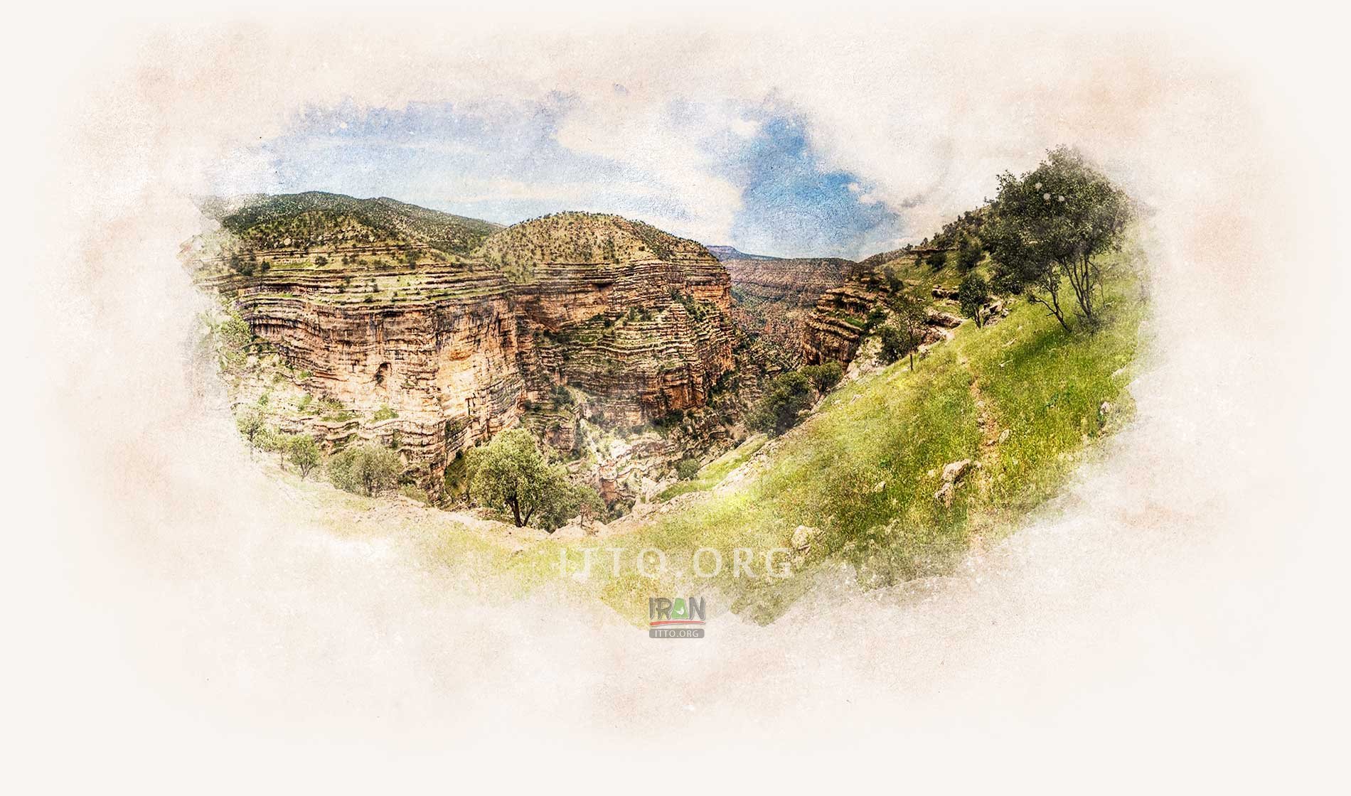
The Shirz Canyon (Tange-e Shirz) is a canyon of geotouristic importance, located 45 kilometers northeast of Kuhdasht, the capital of Kuhdasht County, in the province of Lurestan, western Iran. The valley's springs join the stream of Seimare, which is a branch of the Karkhen River.

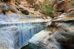
This valley located in Lorestan province, is a very beautiful and exciting valley. in the section of this valley, there is a natural tunnel with a length of approximately 50 meters, that named as the "bridge of God",the trekking of this valley not need the technical equipment.
 
Shirz Canyon - Koohdasht
Lorestan Province is known for its natural beauty, and Shiraz Valley, located about 45 kilometers (28 miles) north of the town of Kuhdasht, delivers just that.

Shirz canyon is located at the intersection of the three provinces of Kermanshah, Ilam and Lorestan, exhibiting some of the most beautiful landscapes and wonders of the area. This canyon has longitude of 5 kilometers and flows through the river that streams to the Seymare River.  This place is surrounded by walls with a height of 150 to 200 meters. The slope of these walls begins at an altitude of less than 10 meters.

The coexistence of the rough and sharp rocks with the trees in the canyon is very interesting. The erosion of rocks and stones in this region has created a special interesting shapes. Fissured limestone walls have been eroded due to rain and therefore black streaks have appeared in this valley.
 
Shirz Canyon (Shirez Valley) - Koohdasht
Life-giving springs, rolling rivers and beautiful waterfalls have given the pristine nature a spectacular view of the area. The name of this spectacular Shirzankiv region, which shines like a Neghini among Iran. This strait is 5 kilometers long and flows through the river that joins the Seirra River at the entrance to Shirz River.

Geographical Situation:
The Canyon is located near Kohdasht city in Lorestan province, in the district of Zardalan. This strait is located on the eastern side of the Zard Mountains and near the Seymareh River, the main branch of Karkheh.
Fullscreen Map
PHOTO GALLERY
Shirz Canyon (Shirez Valley)
Shirz Canyon - Zagros Mountains
Shirz Canyon
Shirz Canyon (Shirez Valley) - koohdasht
Shirz Canyon
Shirz Canyon - Zagros Mountains
Shirz Canyon - kouhdasht
Shirz Canyon
Shirz Canyon - Lorestan
Shirz Canyon - Koohdasht (Lorestan)
21
More Photos
Koohdasht Attractions & Tourist Information
The township of Koohdasht (Kuhdasht) is located to the west of LORESTAN province. Archaeological studies in areas such as Sorkhdam, Lori, Hamiyan and Sartarhan have revealed that Koohdasht was one of the centers of civilization of ancient Iran. The discovery of an Assyrian ...
EXPLORE OTHER ATTRACTIONS IN Koohdasht
Category: Plains
The plains of Koohdasht are to the west of Lurestan province, experiencing semi-warm summers and moderate winters. The Kashgan river flows through this vicinity ...
Category: Bridges
The above mentioned bridge is situated on the old road of Tehran to the ancient city of Shahpour Khast. This bridge has been constructed on Kashgan river. At the ...
This valley lies between two mountains, 80 km. south west of Khoram Abad towards Koohdasht. In the mountains of Sefid Kooh is a crypt which has pillars and a wall ...
Changary is a name of a mountain, which extends from the north-east of Koohdasht till the Seimareh River. On the peak of this mountain are the remnants of a few ...
These two hillocks are situated in the village of Rumashkan (Kooh Dasht).Relics that have been discovered in the Choqa Sabz Hillocks co-relate with the vessels ...
This hillock is situated 6 km. north west of the city of Alishtar and rises to an elevation of 20 m. Relics from this hillock are relevant to various civilizations ...
ON THE SAME CATEGORY
Darband (Tehran)
One of the best Tehran's Outdoor Experience: The beautiful nature of the strait includes the twin Waterfall which is a walkway to enjoy fresh nature for both local ...
Tandis-ha valley, meaning the valley of statues, and its surrounding located at Salakh rural district along the northern coastline of Qeshm Island in Persian Gulf, ...
Mount Damavand (Damavand)
Damavand Mountain, a potentially active volcano, is a stratovolcano which is the highest peak in Iran and the highest volcano in Asia. Mount Damaavand is the 12th ...
Category: Mountains, Lakes
Hezar Masjed Mountains are a group of mountains that form the southeastern section of the Kopet-Dag Range. Located about 40 kilometres east of Quchan and 70 kilometres ...
Category: Mountains
These mountains form the two branch ranges of the central Alborz Mountains, and are the highest sections of this range. To the north, after the Kahu (Sefid Ab) ...
Sahand Mountain (Tabriz)
Category: Mountains
Sahand Mountain (Kuh-e Sahand) with the height of 3707 meters (12,162 ft) is the highest mountain in East Azarbaijan Province, in addition to being an important ...
REVIEWS
Loading Content
Your Name [required]:
Your Email [required]:
Subject:
Your Message:
Please enter this code:
SEND
Copyright 1995-2005, Iran Tourism and Touring Organization, 2005-2024 Iran Travel, Tourism and Touring Online NGO. All rights reserved.